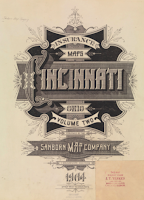
This is a really cool find, thanks to @GeekJames on Twitter (who also tweets as @TakeTheCakeCafe). It is the two volume set Insurance Maps of Cincinnati, Ohio.
First off, I love the cover design. The Public Library of Cincinnati and Hamilton County offers both volumes in their Virtual Library. This was printed in 1904. But looks like it was updated through about 1930. They are very high-resolution scans, therefore each page is a separate PDF (2-4 MB in size). Both volumes have indexes, and it is easy to find the correct plate from those.
Here is plate 100 from Volume 2, which is a guide to volume 2:
I also loved the plate that had the old Fountain Square. You can also see the Albee Theatre and the Hotel Gibson. It is Volume 2, plate 115:
 I forsee lots of time spent looking through these old maps. Be sure to check out the full-sized PDFs of these plates. I resisted the temptation to link directly to the PDFs, but you can find them easily starting at the link above.


13 comments:
Love these! New artwork for my place.
I've used these maps in person before at the library, but I had no idea that some were available online. They are a fantastic resource when trying to figure out when buildings were built or had additions. They note the construction material, the number of stories, and sometimes other items like locations of major rooms even.
What I want would be in volume 3, of course.
:-)
I believe some of these were available to students with university access but its great that this resource is now open for public access.
I was able to find out a lot more about the Heuck Opera House that used to be across the street from my place.
I spent hours looking at these yesterday. The first few of MANY I am sure . . .
The Sanborn Maps were published from 1867-1970. As cool as they are as a computer file, in bound form they are truly awesome. Just opening one requires an entire table, and you can see all the corrections and pasting that went on as buildings were demolished or new ones were built. Both the Downtown public library and the Cincinnati Historical Center have copies but beware: the librarians hate dragging them out because they're so heavy!
Wow, I can't wait to see these in person.
The Main Library has them unbound in flat files - easily accessed.
"I was able to find out a lot more about the Heuck Opera House that used to be across the street from my place."
I was thinking that was the Ensemble Theatre but I was off a block. It's really interesting they list Night Watchman & chemical extinguishers. Well, it's for insurance companies. Would city emergency departments have used these, too ?
I think so Quim, I've always heard these described before as the "Sanborn Fire Maps".
And interestingly enough the Ensemble apparently used to be "Union Savings Bank and Trust Co." if I'm reading this correctly.
As far as the Heuck Opera House goes, it was a very large building that stretched from Vine to Republic and filled that entire void that is a parking lot today in the 1200 block of Vine (next to Metronation). According to photos on Historic Aerials it was torn down sometime between 1954 and 1968.
There was also apparently a very large and ornate bank on the SE corner of 12th and Vine that there are several photos of on the Cincinnati Memory Project... now lost as well.
The first batch of Volume 3 maps just got posted:
http://virtuallibrary.cincinnatilibrary.org/virtuallibrary/vl_Maps.aspx?ResID=675
^thanks. this is how our Public Library continues to be a fantastic resource.
After you get the rest of the volumes scanned (including the older ones) can you somehow digitize the old City Directories and make them searchable?!!! That would be awesome!
I agree with ^ guy. While the property I was looking for was $&*! blank, I found another one that led me to a story about a guy who pioneered junk bonds & bought a major five & dime.
cool
Post a Comment