 And whereas the eastern side has a nature center, an arboretum, a treehouse, marked trails and lots of picnic shelters, the western side is hardly marked. I've hiked much of the eastern side, and one interesting loop is the one that follows close to the highway described here. here are some good photos of the eastern side
The western side of the park has several access points on Westwood Northern Boulevard including a very nice Maple Ridge Lodge on Lucas Road. The other access points here are the McFarlan Ridge shelter, which has a locked gate, and the popular dog park:

McFarlan Ridge Road, Location in Google Maps
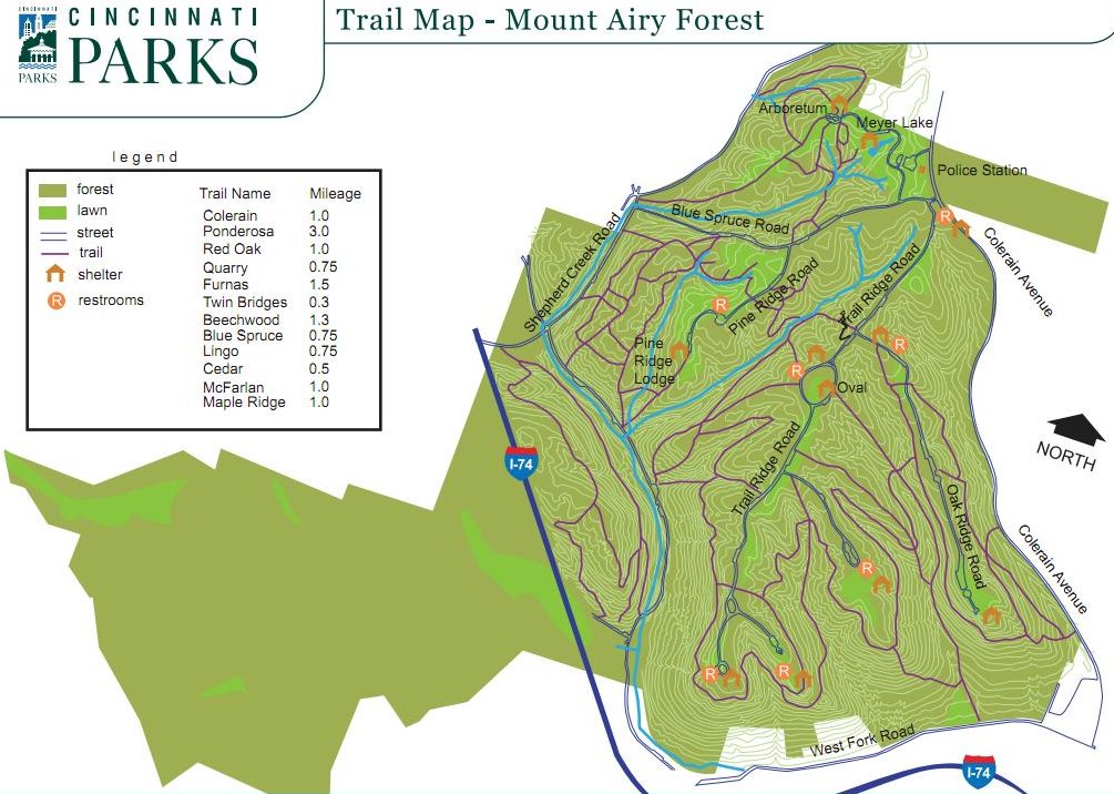
This side of the park is bordered by Montana, Westwood Northern, Diehl, Shepherd Creek and Interstate 74. It is quite a large area, and despite the website showing no trails, there are extensive trails though the area:
 There is an old trail map mounted on the Maple Ridge Lodge if you feel you need it, and here is a website that describes trail "E".
Here are some photos from our hike:
Typical trail with fallen trees and mostly dry creek below trail


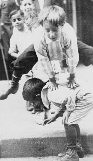
son finds a hollow Sycamore

old trail marker

orange blazes mark one of the trails:

Lower trail, the creek is flowing. This is one reason it is good to go in the late winter or early spring. In the summer, all this could be dry, and less exciting for a kid, although when dry there is good fossil hunting in the stream bed:

On the northern edge of the park, along Diehl Road, Green township is developing a huge new park with more structured activities. The new park, called Bicentennial Park has been under construction for the past year or so and should open soon. The old house on Diehl in which Marge Unnewehr lived before she became Marge Schott, is actually a very early farmhouse built by pioneer farmer Peter Diehl in 1835. Green Township has rehabbed the house and will offer it for rental use.
In the map below you can see the old farmhouse and how a few years ago, it was surrounded by woods:

In a more recent aerial, you can see how much earth must be moved to create some flat playing fields in this very hilly area. The Diehl house is in the upper center of construction, along the road:


13 comments:
It's a neat park with a lot more history than you might expect. It's good to see that the city is entertaining the installation of mountain bike trails in the west half of the park.
I hiked the part of the park between West Fork and I-74 about this time last year looking for the graded right-of-way of the Cincinnati Western Railroad. Part of the trail near the parking lot off West Fork runs on the old grading. http://homepage.mac.com/jjakucyk/Transit1/cw/index.html It's not a pleasant or easy hike when it's wet though. The farther north you go through there it's completely shaded and very muddy.
^I take it the grading kinda follows the creek in that area, and is not higher up?
I think we did almost all of the county park trails last year, but have been meaning to explore the city ones more. I've been somewhat intimidated by the complexity of the trails, or at least, how complex they look on the maps. I like getting "lost" in the woods, but not LOST in the woods. :)
The grading is about 1/3 of the way up the hill from the creek. If I recall I think it's the upper part of the trail that connects to the parking lot. The railroad was to start climbing in South Cumminsville, go through a partially completed tunnel under Fay Apartments, cross Montana Avenue on a trestle, and continue climbing through that stretch of Mt. Airy Forest. It would then cross West Fork on another trestle near Kleeman Court, and proceed almost due north through Monfort Heights East, White Oak East, and Northgate to I-275 and Triple Creek Park. The map on my transit website shows the route.
I hiked behind the dog park once. Got a little lost trying to follow the trail. Eventually made it back to the road and then to the Dog Park!
I believe that part of Mt Airy will soon have mountain biking trails. As a biker, maybe, we'll let a few hikers use the trails too. ;-)
http://www.joinomba.org/cora/index.php?option=com_content&task=view&id=140&Itemid=1
Just a note to all the hikers/bikers who wish to use the trails on the west side of Mt. Airy Forest - these are 'Bridle Trails' and horse folks do use them. So please be kind and keep your dog on a leash and heads up for horses!!
^what? these are horse trails? Are you sure?
I'm interested in running the East side trails at Mt. Airy (never ran at Mt.Airy). It is May 3rd today and as anyone can attest to it has rained for quite awhile lately. Question; How quickly would you expect the trails to dry out so I'm not cover head to toe in mud and clay after my run?!
This has been one of my favorite areas to hike lately... Lots of room to wander and multiple ways in and out. I have a map of the trails that looks like it was on the Cincinnati Parks site, but I can't find it there now, so I put it up here: http://www.palas.com/~brand/MtAiryWest.jpg.
Incidentally, the map in your post above appears to show the most difficult way into the area -- a very long, low tunnel under the interstate that connects to the West Fork trail.
cheers,
Karl
Yeah, I don't think I would go in that drainage tunnel, but I was trying to show where the road went before it was cut-off by the freeway.
It's definitely an interesting experience going through the tunnel... But getting in/out of the east end involves a somewhat hazardous climb over a deep pool of water.
Post a Comment