Showing posts with label streets. Show all posts

17 October 2011

Obesogenic Motorgenic Cincinnati

I want to do what is good, but I don't. I don't want to do what is wrong, but I do it anyway. - Romans 7:19

I believe this newly invented word obesogenic is helpful in thinking about how our environment and culture affect our individual bodies. I have had times in my life in which my environment was much healthier, and as a result I was physically much healthier.

For example, in 1986 (I think), I lived for a few months in Spain. While I was there, I had no access to fast food, junk food or even any dairy products. However, I ate whenever I wanted and drank whatever I wanted. I found when I returned home that my clothes were all loose and I felt fantastic. My tastes in food had even changed. Since then, I have tried to recreate that diet, but it is difficult because diet is so integrated into our culture and lifestyle.

I find more and more that the idea that we are all independent and that we are each as individuals totally responsible for our well-being to be false. Yes of course I am responsible for my own actions, but it is an acutely American way of thinking that disallows common action for improvement.

For example, I hate bike riding,... at least in Cincinnati. Yes the hills are one reason, but mostly I ride in the basin, so that is not the main reason. It is just way too dangerous, especially with children. And to take two kids with me on bikes is a huge ordeal. Just getting 3 bikes out the door with 3 helmets and bike locks and lights if it is dark, is just ridiculous. And downtown is not much different than many suburban areas (except that you have a garage to keep all the bikes). I really don't see that many suburban kids out riding beyond their cul-de-sac... because cars rule and it is too dangerous. Nothing like this.

I saw an item a few weeks ago a woman was prosecuted after her son was killed by a car while jaywalking. Frankly, I don't think jaywalking should even be a crime on any residential street. The prosecution of this poor woman is just an indication of how backwards American thinking is about walking vs cars. Cars rule, period.

We live in a motorgenic environment. Motorized vehicles rule our public streets and pedestrians and bicyclists are scared and pushed to the fringes. This attitude ruins cities. It destroys shopping streets, public spaces, streets and sidewalks.

Cars and walkers can only successfully mix if the actions of the car are restrained and the actions of the walkers and bikers are liberated.

We need to change from a motorgenic environment to a muscle-powered, socially oriented, pedestrian friendly environment.


‘We live in an obesogenic environment – a plethora of fast food outlets, reliance on cars, and offers enticing us to eat larger portions …’Professor Mike Kelly – as quoted in the Telegraph 8th October 2003

Join the movement to move your feet

14 January 2011

Sidewalk Gas Pumps

This photo is of a common gas pump configuration found in some European cities. Compare this to the typical gas station which is hazardous to pedestrians.


I got this photo off of an email listserve last year and I cannot remember who took the photo or even what city it was taken in.

11 October 2010

Moving People vs Moving Cars NYC


"Once you realize that you can use your street to imporve the quality of life, the economic health of your city...I thin that's a transformative moment..." _ Janette Sadik Kahn, Commissioner of NYC DOT

After 3 year of implementing this plan, traffic fatalities are down 20%

30 August 2010

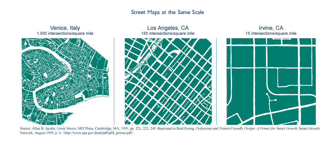
Intersection Density


The Power of Intersection Density

Intersection density is the number of intersections in an area. It corresponds closely to block size — the greater the intersection density, the smaller the blocks. Small blocks make a neighborhood walkable.

...Of all the built environment measurements, intersection density has the largest effect on walking — more than population density, distance to a store, distance to a transit stop, or jobs within one mile. Intersection density also has large effects on transit use and the amount of driving...

Continued here

28 May 2010

Permanent Parking Day

This short video is about taking poorly used space away from cars and re-claiming it for parks, bicycles and people:


Here is another example in Texas.

See the after and before photos:


On a related note, has anyone else seen these videos made by artist Ross Ching, showing LA without cars (also without people):

Running on Empty from Ross Ching on Vimeo.

10 May 2010

Permeable Pavements

I've been noticing the City's Engineering Department has initiated a project to install water permeable pavements in some locations. This is a fantastic development.

Solidly paved surfaces treat rainwater as a waste product. Rain is typically channeled and piped away as quickly as possible. This is a problem because the vegetation (street trees mostly) needs that water.

Also, all that channeled rainwater overwhelms our combined sewer system during heavy rains. Any water diverted from the storm pipes save the City headaches.

So I noticed that last week during a heavy rain, that no water was being channeled down Comer Alley. Comer Alley is a one-block alley that parallels Race Street and runs between 14th and 15th. It was re-built last year as part of the OTR Community Housing Project "City Home". It was rebuilt to make it easier to use so that vehicles could access new rear garages. Before, the alley was only eight feet wide between granite curbs, and this made it very tight in which to drive a car.

The Alley bricks were removed, and a permeable gravel base was installed. Then the old bricks were re-installed level with the granite curbs. When the bricks were reinstalled, slight gaps were left between the bricks and filled with gravel. These joints absorb all the water and direct it into the ground. It is a beautiful solution to several problems.

Here is a picture of nearby Osborne Alley, half-done:


See here for some during construction photos of the alley.

I also noticed that a similar effort was made at University of Cincinnati, near trees. Notice that here, the pavers are laid in a different pattern above the tree roots, allowing water to enter the ground:


UPDATE: Here is a great article about permeable alley pavements in Chicago

30 April 2010

Austin Like Portland

My wife was in Austin, TX last week, and she sent me these two photos because they struck her as similar to scenes in Portland, OR, which we visited together a few years ago.

First here is an extra wide sidewalk:
 
Some effort was made here to narrow the part of the right-of-way that is for driving and widening the sidewalk. This was also done in areas of Portland.

Secondly, these look a lot like new condos you would find in Portland's Pearl District:
 

29 April 2010

Street as Playground Inspiration

A post about a new playground in Paris was forwarded to me by a reader. I really like custom designed playgrounds, especially when it's not all rubber surfaces. Apparently this playground has been wildly popular with the kids:


But the most fascinating part about this playground is not the hard surfaces or how wildly popular it is. The most fascinating tidbit is the designer's stated inspiration: A Willy Ronis picture from 1959 of kids playing in a street:
Belleville that was an inspiration for the playground:


Obviously, the "street" in the Ronis photo is not a typical street. It is full of levels, steps, different materials, surrounding shops and such. It is really a medieval type street in a old neighborhood of Paris. Actually I think it is not too far from the new playground site above. It is not a street designed by a traffic engineer. But although the street is extremely pedestrian friendly and kid friendly, it doesn't have any trees, benches or signage, things that today are assumed necessities.

Kids on the concrete:
 
Anyway, it brightened my day to see someone making these connections and thinking about playgrounds in a different way.

01 April 2010

Fifth Street Closures


One of the significant changes to Fountain Square during it's reconstruction was the replacement of a steep wall along Fifth Street with shallow steps. This change opened up the square to Fifth Street. This gave me some concern at the time, because cars can travel pretty fast through this block, and there was no barrier to keep kids or others from walking out into traffic.

But there was a flaw in my logic. The old wall supported the notion that the street is meant for fast cars, and that we the pedestrian must be separated from them at all times. The better approach is to tame the car, not the pedestrian.

To that end, Council has passed an ordinance encouraging the closure of this block on some weekends. I hope this becomes a regular event in the summer, and I hope that other ways of reclaiming our public streets are found.
Qualls’ motion will create pedestrian-friendly Fifth Street

Fifth Street between Walnut and Vine Streets will be closed to through traffic to create a more pedestrian-friendly environment near Fountain Square for two upcoming festivals; if successful, the change could be expanded to include more weekends next summer....

“Streets are really the public living rooms of our communities,” Qualls said. “This will enhance what’s already a great public space in downtown by creating a richer variety of uses and activities in an environment where people feel comfortable, safe, and sociable.”

“Public spaces don’t have to be defined by parks or squares, said Fountain Square Managing Director Bill Donobedian. “The city has so many assets that can be repurposed so we can get more out of them. If we step back and ask ‘what if,’ Cincinnati can be as exciting and dynamic as any city, if not more so.”...

Cities across the United States are working to make public urban spaces with heavy pedestrian traffic more pedestrian-friendly by closing them to vehicular traffic, Qualls said. The most famous successful example is New York City, where Mayor Michael Bloomberg announced in February that the city would make the eight-month-old pedestrian plazas in Times Square and Herald Square permanent. The Broadway closure that created the plazas result in improved pedestrian safety and foot traffic – a 35 percent decline in pedestrian injuries, and a 63 percent reduction in injuries to drivers and passenger; foot traffic in Times Square increased 11 percent and in Herald Square by 6 percent, according to city data. The city banned vehicles on Broadway from 47th to 42nd Streets and from 35th to 33rd Streets...

16 February 2010

Igloo in Over the Rhine


A 12 foot wide sidewalk is sometimes big enough for a playground.

14 January 2010

FTA to Include Livability in Funding Decisions

Although this kind of policy decision is not very sexy and it will not make the evening news, it is a critical change to the way Federal Transportation dollars are allocated. Via tha FTA website:

Obama Administration Proposes Major Public Transportation Policy Shift to Highlight Livability
Changes Include Economic Development and Environmental Benefits

In a dramatic change from existing policy, U.S. Transportation Secretary Ray LaHood today proposed that new funding guidelines for major transit projects be based on livability issues such as economic development opportunities and environmental benefits, in addition to cost and time saved, which are currently the primary criteria...

“Our new policy for selecting major transit projects will work to promote livability rather than hinder it,” said Secretary LaHood. “We want to base our decisions on how much transit helps the environment, how much it improves development opportunities and how it makes our communities better places to live.”

... “No longer will we ignore the many benefits that accrue to our environment and our communities when we build or expand rail and bus rapid transit systems.”...

14 November 2009

Index of Cities with Dangerous Streets

In the last 15 years, more than 76,000 Americans have been killed while crossing or walking along a street in their community. More than 43,000 Americans – including 3,906 children under 16 – have been killed this decade alone. This is the equivalent of a jumbo jet going down roughly every month, yet it receives nothing like the kind of attention that would surely follow such a disaster.

... These deaths typically are labeled “accidents,” and attributed to error on the part of motorist or pedestrian. In fact, however, an overwhelming proportion share a similar factor: They occurred along roadways that were dangerous by design, streets that were engineered for speeding cars and made little or no provision for people on foot, in wheelchairs or on a bicycle.

... The forthcoming rewrite of the nation’s transportation policy presents a once-in-a-generation opportunity to create safer streets that will be critical to keeping our neighborhoods livable, our population more fit and our nation less dependent on foreign oil...

...Congress is currently considering the goals and objectives for a federal transportation bill that will send transportation money to states and cities and guide their spending priorities. The continued high fatality rate shows a clear need for strong leadership and greater resources to end preventable pedestrian deaths and require more accountability from states on how those funds are spent....

28 October 2009

NYC Bike Lanes

Great video explaining the bike paths in New York City. The paths range from Class 1 which is a protected path separated from traffic with parked cars, to Class 3 which is a smaller, shared street. I have heard from associates in NYC that the pedestrian and bike friendly redesign that is expanding all over Manhattan is making the streets much more usable.

03 October 2009

311 See Click Fix

There is a movement afoot to encourage citizen participation in correcting neighborhood problems. Some cities have a 311 number and some have developed iPhone applications whereby you can notify city departments about litter or maintenance issues. There is a general iPhone app called See Click Fix which affixes the photo to a geographic location and assembles the complaints onto a map. Then, what is supposed to happen is that a city worker pulls the data and sends it to the relevant department. Seems like there is a lot of potential here to get more power into the hands of the people regarding everyday annoyances.

Article in NY Times.

iBurgh, Pittsburgh's effort

23 August 2009

Our Roads are Designed to Kill

... they asked, “This is where you live? This is your neighborhood? Your streets are designed to kill people.’’ They said that the thin painted white lines at the intersection could not be seen at dawn, nor was there a raised bump to or a narrowing of the road to demarcate the intersection and slow down traffic. They said the speed limit should be ... less if we wanted pedestrians to have much of a chance of surviving. They also said traffic lights increased the number of deaths because people often speed up when the light turns yellow...

... these deaths were not “accidents’’ but were predictable and preventable. And they set out to prove it.

...Most people think we are doing all that can be done to keep our roads safe. They are wrong. Road traffic injuries kill more than a million people a year worldwide, including 40,000 a year in the United States. ... we can change our roads so they help protect both drivers and pedestrians...
From here. More here.

11 August 2009

Guess This City


Park in center of town:


The back of a very strange civic building:


Lots of coffee shops in this town:


Segways:


Bar on Sidewalk:


Interesting Building:


hippies here are anti-cop:


across the street, the City Police Station:


13 July 2009

Thanks Mainstream Media... for this.

OK, so if I'm going to complain, I better step up and applaud. The Enquirer just ran a piece called Streetcar film comes full circle on an upcoming showing of a 1996 documentary on Streetcars that is critical of GM's role in their demise. Enquirer reporter Lauren Bishop interviewed Jim Klein, a Wright State University professor and documentary filmmaker who helped produce the film.

In the answer to the first question he said:
What I discovered in making the film is the type of transit you have impacts the type of city you have. A city that has more opportunity for its citizens to travel around with each other and for neighborhoods to be places where business takes place rather than the car-oriented, mall-oriented type of society, I think is a lot healthier and has a lot more long-term potential.
Go to the Enquirer story for more details, it is worth the read. You can see the movie at the Carnegie Visual and Performing Arts Center this Tuesday and Wednesday at 7:00 pm.

06 July 2009

Russ Alley

 
I think I know OTR pretty well. But everyday I notice new things. Sunday, while walking down Republic Street, between Green and Liberty, I noticed this gated alley. I am generally negative on privatized public space, but was pleasantly surprised by this short section of alleyway. Places where 2 alleys intersect in the middle of block are usually pretty unsafe places anyway.

I think all the buildings that surround this alley are part of a project called St. Anthony Village, which is a "renter equity program" consisting of 28 apartments. From what I have seen, it is a peaceful part of the neighborhood.

Here is Russ Alley on an auditor's map. It runs e/w below the yellow highlighted building and a few other buildings. The gated section runs from Republic Street to Goose Alley:


1635 Republic, gate on alley:


The eastern end of the alley, here unfenced to the left of this red building, runs out to Vine Street:  

09 June 2009

In Favor of Walkable Neighborhoods

A post on the NY Times Health blog This Old (Healthy) House talks about a study that attempts to look at the affect of where you live on BMI. From the post:
University of Utah researchers found that people who live in older, more walkable neighborhoods are at lower risk for overweight and obesity.
I found this paragraph especially pertinent to recent discussions on things like complete streets:
They found that neighborhoods built before 1950 tended to offer greater overall walkability because they had been designed for pedestrians. Newer neighborhoods often were designed primarily to facilitate car travel, the researchers noted.
Follow the links to the post and study for more details.

04 June 2009

Complete Streets Event


Tuesday, June 9th at 6pm,...Roxanne Qualls will be (at the Mercantile Library) to discuss Complete Streets...with planner Clete Benken of Kinzelman Kline Grossman. ... Mr. Benken will be here because his firm is in the street fixing business and is responsible for the plan that will restore two way streets to Lexington, so he may have a few things to say about Cincinnati’s vehicular sewer system. It’s going to be great. Worth every one of the eight dollars to be charged. You’ll need a reservation by tommorrow, Friday, June 5th....513 621 0717.